


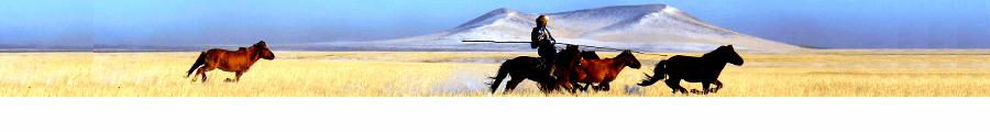
Baga Landstone Baga Gazriin Chuluu in GOBI DESERT
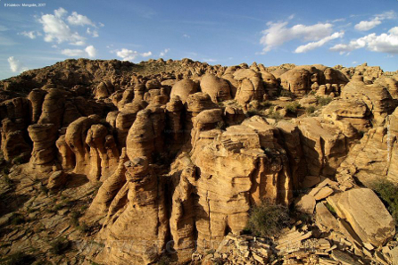
Baga Landstone is located in the territory of Dundgov Province and rises 1768 m above sea level.
Location
It is located in the center of Dundgov province, 230 km from Ulaanbaatar. It is a mountain formation with rocks and stones with an area of about 300 square meters, without high mountains. The highest peak is Tahilgy Gorge, which rises 1768 meters above sea level. In the middle of the mountains covered with granite stones that looked as if they had been laid out, there were springs and springs flowing from the mountains in the valleys and valleys.
A historical monument
There are many places of interest for tourists in the mouth and valley of Baga Land Stone Mountain, such as Jargalant Cave, Sedoti Mouth, Eye Spring, Ger Khad, etc. There are Bronze Age petroglyphs on a small rock called Ger Khad, southeast of Baga Land Stone. Small animals resembling yaks, bows and arrows, humans and dogs have been carved. Not far from it, two deer are depicted on another rock, and this picture, 170 cm long and 90 cm wide, is considered a major find in the province.
Jargalant Cave is located at the foot of a small stone hill in the northeast center of the Great Lowland Stone Valley. This cave is 18 meters long, with a large mouth about 2 meters in diameter, where rainwater flows under the rock. In this area there lived an old man with only one goat, and the goat went into a cave and disappeared. It is said that the cave was closed in a narrow area of about 3 meters to prevent people from entering again. Apricots grow around the cave and look very beautiful when they bloom in spring and summer.
Others
About 1 km away from Jargalant Cave, rainwater is collected in a narrow borehole about half a meter deep, which looks like it was deliberately drilled on a steep cliff, and is called Eye Spring by the locals. It is said to be beneficial for people with eye diseases and blindness. Large herds of argali and ibex and herds of antelopes graze in the plains behind the mountains.
More information about
Baga Landstone Baga Gazriin Chuluu gobi desert.
And location, check to
other gobi deser tour itinerary.
WHITE STUPA in GOBI DESERT
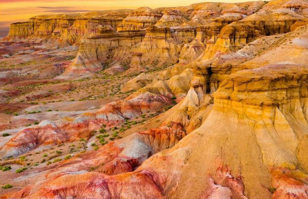
Tsagaan Suvarga is a unique and beautiful scenery in Dundgovi that attracts both foreign and domestic travelers. This lovely place is one of the Nine Wonders of Dundgov Province, which is so beautiful that not only the Gobi region can show off Mongolia to the world. This is the beautiful clay wall canyon of the Great Gobi, the great beach of the Early Paleolithic, and the beautiful stupas of the Great Gobi. Tsagaan Suvarga is located in Ulziit Sum, 156 km south of the provincial capital. Any mountain, shrine or stupa can be seen from any direction, but Tsagaan Suvara is not. From the front, the flat plain becomes a sharp gap. If you go uphill from the right side and look to the left, you will see a wonder that you have never seen before. Many years ago, the silt layer at the bottom of the sea was shaped like this by the wind. The height of the platform is about 60 meters and its length is about 400 meters. 90 degree straight male. From a distance, the city of Tsagaan Suvarga looks like ruins and buildings. If you watch the sunrise from there, you will be immersed in a rainbow of colors, and you will feel the peace and good feeling as if you were there in early summer. Local people sometimes describe Tsagaan Suvara as an "energy center". Seven kilometers to the east of the Tsagaan Suvar, there is a cave of the Horizontal Vertical in the middle of a low hill. The length of this cave is 50 meters. The characteristic is that when entering the cave, you enter it vertically, and when you come out of the cave, you have to go almost horizontally. The cave is of interest to cave explorers because it was formed by the erosion of water in the clay, and it is 102 meters long, according to Dr. E. Avirmed. A large cave with an area of 204 m/sq. Anyone who comes to Tsagaan Suvarga visits the horizontal and vertical cave. In addition, travelers can climb through the petroglyphs and inscriptions of Khokh Tsav and Del Mountain, as well as visit the legendary places where the good man of glass lived, such as Deroo Hanginah and Hongor Khairkhan, natural and historical monuments, and relax. White Suvarga, Gobi Suvarga and Gobi CaravanSerai Tourist Camps operate based on this natural beauty of Tsagaan Suvarga. Great Gobi exhibition, mud-walled canyons that look like a wonderful fairytale land, elaborate clay mounds, the edge of the early Galva sea, wide Great Gobi exhibition, perfect stupas, 70-meter-long horizontal vertical cave, melted groves and sand dunes that are rare in Gobi region. sure to delight the eyes of every guest. More information about white stupa gobi desert. And location, check to other gobi deser tour itinerary.
BAYAN ZAG in GOBI DESERT
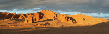
Bayanzag (Another name is Ulaan Ereg) — from Bulgan sum of Mungogov province.[1] to the east of the Juniper Mountains.[2] a place with clayey sediments in a vast valley belonging to the mountainous region of Gobi. It is world famous as a place where rare paleontological fossils have been found. In addition to many dinosaur eggs, dinosaur nests were found here for the first time in the world. In addition, remains of velociraptors and dozens of other mammals have been found.
Formation
It stretches from south to north, it is 5 km wide and 8 km long. Mongolians call Tsav the place where the red sandy clay soil has hardened. A little higher place is called Tsonj. The height of Bayanza trees is from 20 to 50 meters. According to the shape of the structure, the locals call it Table clay [3] and Camel clay [4]. There are places called etc. Act.[5] It was named Bayanzag because of its wooden forests. The sago tree rarely grows taller than 2 meters, and its branches grow in various ways. Because it is the most calorific tree, the people of Gobi call it "Urgaa coal".
History and nomenclature
of Bayanza.[6] Many artifacts have been found that prove that ancient people lived in groups in the area. Researchers have established that people lived 40,000 years ago. Also, in the southern part of Bayanza, the whole bones and eggs of a giant dinosaur that lived 60-80 million years ago were found, which was a shock to the world. In 1922, the team of Roy Chapman Andrews[8], a researcher from the United States[7], found a 10-15 cm dinosaur egg for the first time. This find is the first evidence that dinosaurs laid eggs.
In English literature, the name Flaming Cliffs ("Fiery Shells") prevails, and it was given the name by the paleontologist Roy Chapman Andrews, who came here in the 1920s to lead the Central Asian expedition organized by the American Museum of Natural History, because of the bright orange color of the cliffs. The color is especially pronounced at sunset. In other words, Bayanza got its name because the red clay soil looks like a red fire burning in the evening sun.
Bayanza got its name because it grows a lot. Locals also call it Shiree shavar, Temeen shavar, Ulalzakh tsonj [9], and in the documents of the Central Asian expedition, it is called Shavar us.
Location
It is located 550 kilometers south-west of Ulaanbaatar, the capital of Mongolia, 110 kilometers north-west of Dalanzadgad, the capital of Umnogov province, and 18 kilometers east of Bulgansum, in the valley of Artz Bogd Mountain. The Americans who came in the 1920s called it Bayanza Settlement, and the report of the III Central Asia Expedition noted that "...Bayanza Settlement is located 600 kilometers northwest of the Gate City of China, along the road to Hov."
Key dinosaur finds
Velociraptor skull found by paleontologist Henry Osborne on an expedition to the American Museum of Natural History in 1924. The length is 17 cm.
Theropods
Ornithomimosaurs
Tyrannosaurids: Alioram, Tarbosaurus
Dromaeosaurids: Velociraptor, Saurornithod, Mononychus
Therizinosaurs: Therizinosaurus
Oviraptors: Oviraptor
Hadrosaurids: Saurolophus
Protoceratopsids: Protoceratops
In the past, paleontologists believed that Oviraptor stole the eggs of other dinosaurs, such as Protoceratops. Eggs found in Bayanza, thought to be Protoceraptus, were actually Oviraptor.
location, check to
other gobi deser tour itinerary.
Khongoryn Els sand dunes
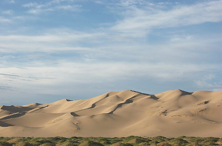
The sand of Hongor is from Sevrei of Mungogov province[2] and Bayandalai subdistrict.[3] It is located in the region of Sevrei and Zoleng Mountains.[4] behind it is a sand dune that stretches for about 180 km. It has a total area of 965 square kilometers, extending from northwest to southeast. The widest part of the sand is 27 km in the northwestern part, and the narrowest is 800 meters in the central part. When you get to the top of the sand dunes, you can see hundreds of dunes. When looking at the entire vicinity of Hongor sand, it is very beautiful to see a rocky mountain in front, a sand dune in the middle where no vegetation can grow, and a green oasis with a river flowing on the north side. The flood water from Zoeleng Ridge made a path through the sands of Hongor and seeped into the soil, and at the northern edge of the sands, Serun Spring[5] and Arganga Spring[6] It forms a stream called Khongor River and flows westwards for more than 10 km along the sand. When traveling through the sand dunes, start at the nearest hill, and it is easiest to follow the crest of the hill from one hill to the other. Because of the loose sand, it is impossible to climb steeply, and the legs get tired easily. There are a number of petroglyphs on the cliffs of Sevray, including a hunter on four horses chasing five ibex. The bow and arrows are simple in shape and may be Bronze Age bows, researchers believe. Of the sand ridges, dunes, and sand dunes that occupy about 3 percent of the entire area of Mungogov province, Hongor Sand is the largest and one of the largest oasis in Mongolia, extending 185 km from west to east along the straits of Sevrei, Nomgon, and Zoolen Mountains. Located at the western end of the Khongor Sands is a hollow and hollow area with strange formations such as reeds, bamboo, turf, reeds, sedges, sedges, sedges, sedges, sedges, sedges, sedges, sedges, sedges, sedges, sedges, and sedges. The sand dunes range from 10 to 195 meters high from the base to the top, and when the wind blows, they make sounds like music. A clear example of this is the sound dunes of the Hongor river. This sound comes from the fact that the fine particles of sand are blown away by the wind and become electrified and its positive and negative electric charges dissipate. The sands of Hongor form a continuous golden mountain with a pointed top, with a spring flowing from the bottom, green grass, and a white lake where herds of cattle graze on its shores. In 2010, Gobi of Mongolia was named one of the "Nine Wonders of Mongolia" representing the province. Duut Manhan.[7]-The highest part of the Khongor sand is called Duut Manhan. The local people gave it the name because when you lie on the sand looking up, you can hear the sound of airplanes flying overhead. More information about white stupa gobi desert. And location, check to other gobi deser tour itinerary.
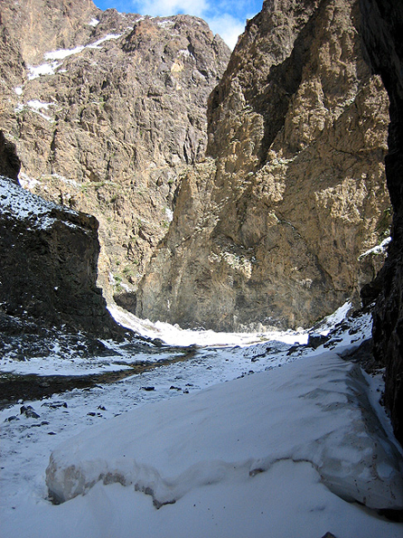
YOL MOUTH in GOBI DESERT
Yol mouth is a deep canyon at the mouth of Dzhun Hsalt in the Govi Gurvansaikhan Natural Park, located in the Umnogov province of Mongolia (45 km west of Dalanzadgad, 650 km from Ulaanbaatar). It is a protected area and the protected area is 64 square kilometers. It is called Yol's mouth because of the rare Yol bird. "Yol Am" is one of the must-visit places for local and foreign tourists. Yol Am, one of the canyons of the Eastern Mountain Range, has permanent snow, which is several kilometers long and several meters thick in winter. However, due to global warming, there has been no snow in September in recent years. Average height above sea level is 2800 meters. The area is 64 square kilometers. Dzungsaikhan Mountain.[1] It is a narrow gorge of a river that flows to the northeast. A small stream flows through the canyon and is covered with ice in winter. There used to be ice throughout the year, but in recent years, due to global warming, most of the ice has melted. In some parts of the canyon where the eternal sun does not shine, ice more than 1 meter thick remains. During the rainy season, 4 waterfalls flowed down from the canyon. Because there are many cool places with eternal shade where the sun does not shine, the refreshing cold air flows through the canyon. Some of the cliff walls of the canyon are as steep as 200 meters high. Mockingbird: a rare bird found only in Central Asia, and hunting is prohibited. It is characterized by nesting at an altitude of 1500-3000 meters. The wingspan reaches 2.0-2.5 meters. The back is bluish-yellow, the head and abdomen are pale, and there is a beard under the chin. It is a very curious and suspicious bird that feeds on animal carcasses and rarely comes down to the ground. Compared to the neighboring mouths such as Muhar Shivert and Dungenee, the mouth of Yol is relatively beautiful, and it is unique in that it can penetrate into the mouth of Bayajih. More information about white stupa gobi desert. And location, check to other gobi deser tour itinerary.
